Gov. Scott: Vermont’s July storm is ‘Irene 4.0’
July 12, 2023 | By Hannah Normandeau | Correspondent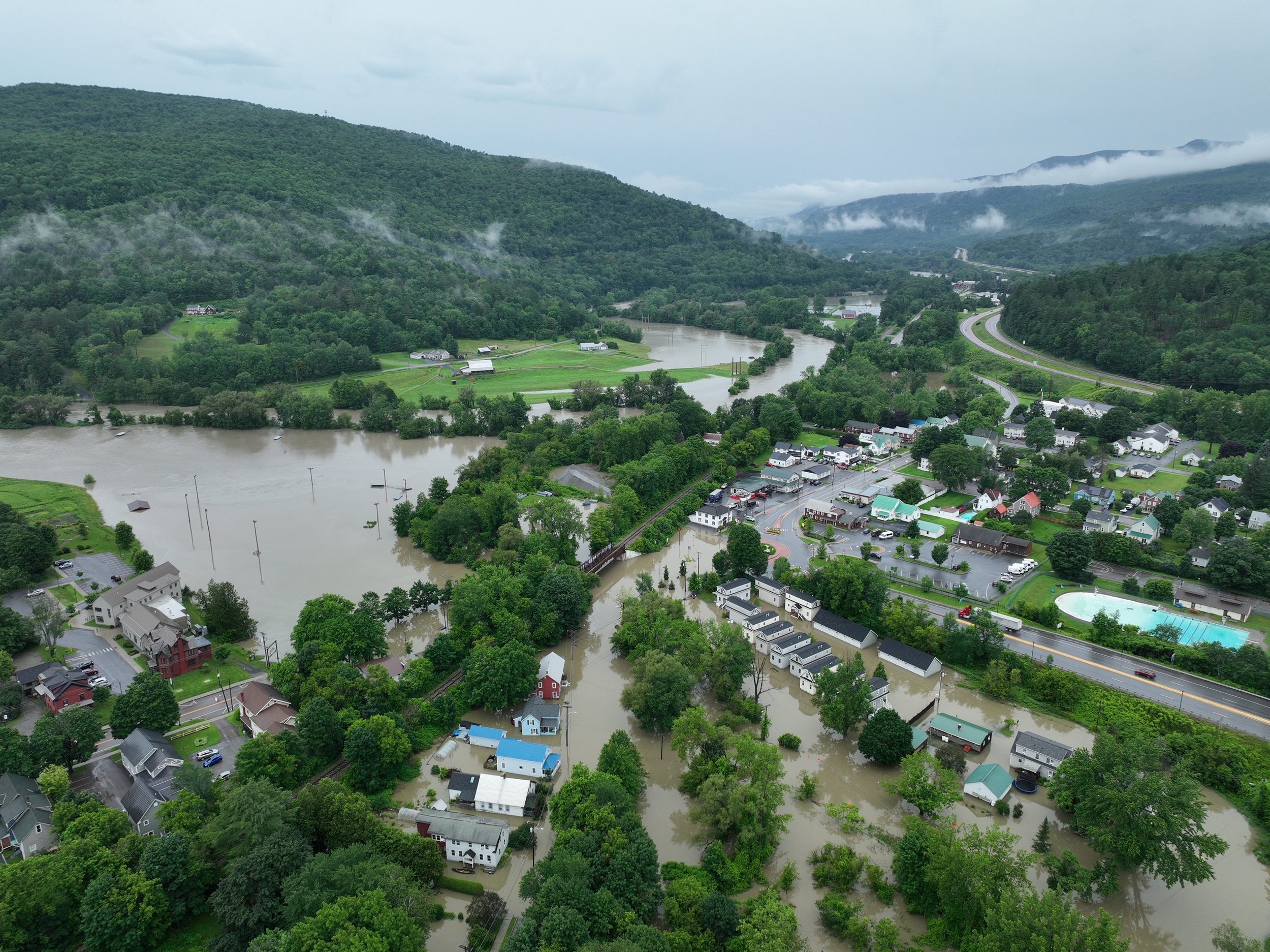
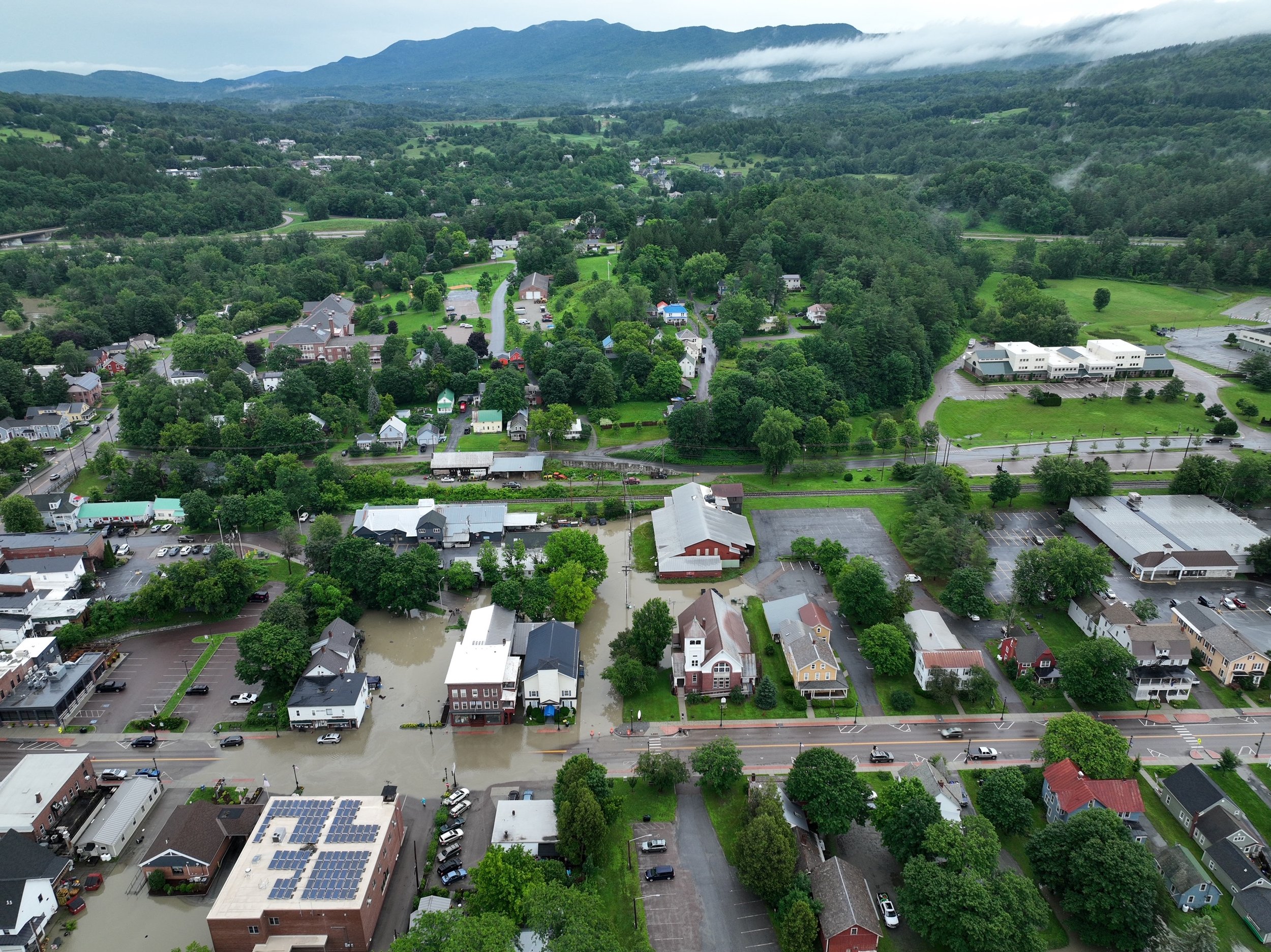
Waterbury’s North Main Street, Dac Rowe Park looking towards River Road in Duxbury and I-89. Photo by Vince Franke
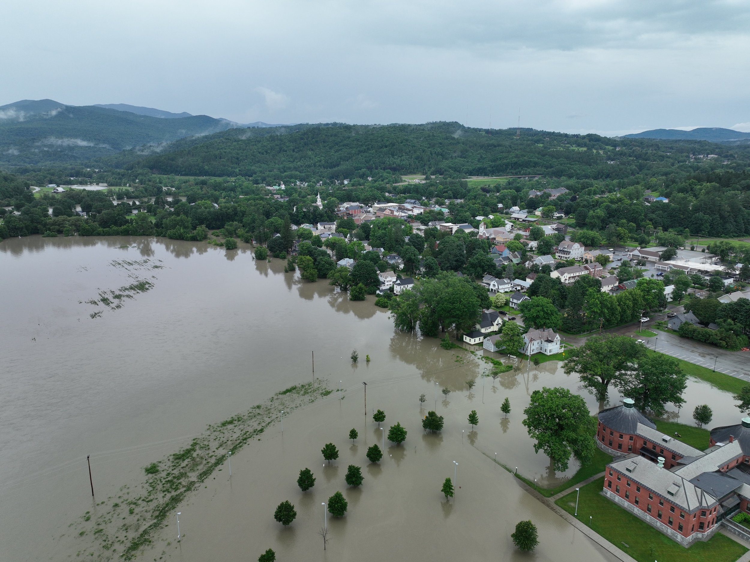
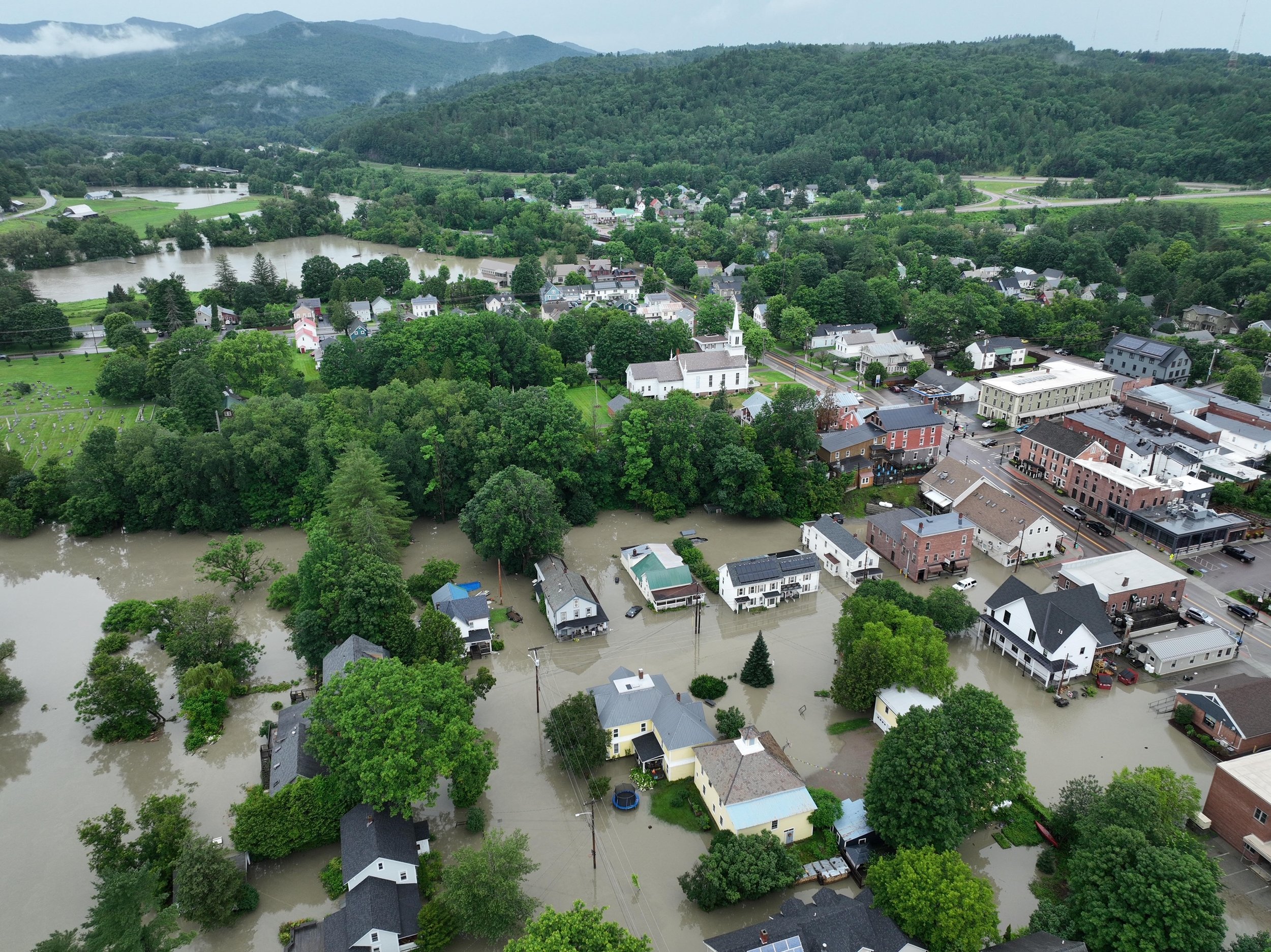
On Tuesday morning, areas of Waterbury village were still inundated with flood waters, rising from the Winooski River and pooling over parts of the roundabout, Winooski Street, Randall Street and Main Street, limiting access to and from the town. Residents in Muck boots and rain gear gathered at the new coastline behind Prohibition Pig, the murky water rippling as two people in a canoe paddled slowly down the street past a white Chevy Suburban submerged to the top of the wheel wells.
Down the road, at what is meant to be the base of operations for the state’s emergency response, the Vermont Department of Public Safety Headquarters was closed, with the Winooski River surging high behind the State Office Complex.


Gov. Phil Scott said in a press conference Tuesday that a decision was made to move operations temporarily out of Waterbury due to road access, as well as to not impact the local response.
“The complex in Waterbury was surrounded by water but it wasn't impacting the buildings themselves. They've been hardened enough,” Scott said. “We'll come back there as soon as the water recedes.”
The governor offered updates on the current situation along with representatives from the Vermont Agency of Transportation, Vermont State Police, Vermont National Guard, Urban Search & Rescue and others. “Make no mistake, the devastation and flooding we’re experiencing across Vermont is historic and catastrophic,” Scott said, adding that President Biden approved the state’s request for disaster declaration for all 14 counties in Vermont.
Vermont Commissioner of Public Safety Jennifer Morrison said the hardest hit areas so far were Barre-Montpelier, Ludlow, Londonderry, Andover and the surrounding communities. As of 9:30 a.m. no injuries or deaths had been reported, Morrison said, noting that an earlier report of a death in Londonderry was erroneous.
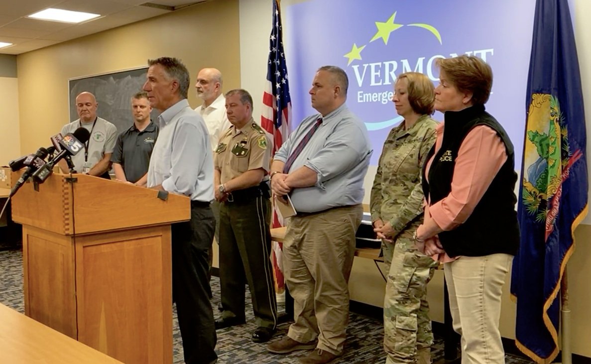
Gov. Phil Scott speaks at a press briefing on Monday. Public safety officials with him include on left, Mike Cannon of Vermont Urban Search & Rescue; Eric Forand, acting emergency response director; Vermont Transportation Secretary Joe Flynn, Deputy Public Safety Commissioner Dan Batsie, Col. Tracey Poirier with the Vermont National Guard, and Public Safety Commissioner Jen Morrison. Screenshot
Vermont's Urban Search and Rescue Program Coordinator Mike Cannon said to date there had been 117 rescues, at least 67 evacuations from flooded homes, businesses and vehicles, and 17 animal rescues conducted by local, state and federal agencies.
Tuesday morning at 3 a.m., a swift water rescue team from New Hampshire performed an “extremely high-risk” rescue on Winooski Street in Waterbury, Cannon said. It involved a woman who had driven around a properly barricaded roadway and the car was washed off the road, “almost into the river.” The team took a considerable amount of time to safely rescue the individual from the vehicle.
By Tuesday, 13 swift water rescue teams were present in the state, plus Vermont Urban Search & Rescue, and at least six teams from Connecticut, Massachusetts, North Carolina, other states and federal agencies working or en route to Vermont “to assist with what will be a days or weeks long effort,” Morrison said.
Other support is coming from the Vermont and New Hampshire National Guards, including five helicopters – two with hoist capacity – plus drones from the guard and Vermont State Police for search-and-rescue efforts and damage assessment.
“We’re operating 24 hours a day and have been since 3 p.m. Sunday,” Cannon said.
What’s next
In the coming days and weeks, Morrison said there will be structural collapse teams staged across the state as well as fire and code inspectors to assess damage. She also said state troopers are deployed, and patrol zones have been adjusted for statewide police coverage regardless of road closures.
“I want to reiterate that we are in the earliest stages of disaster,” Morrison said.
The governor plans to continue regular briefings until the emergency phase is over. He intends to visit communities eventually, “but I don’t want to be part of the problem.”
He said previous mitigation efforts made after Tropical Storm Irene in August 2011 appeared to be working well, citing the lack of bridge and structure failures seen from the previous catastrophic storm, but the local damages would be the worst.
“I think a lot of it is going to be in the communities, in the storefronts, and the downtowns,” Scott said.
‘Irene 4.0’
So is this latest storm, as some are saying, Irene 2.0?
“I think it is,” Scott said. “I’d say it might be more like 4.0” due to the prolonged deluge.
Whereas Irene had less than 24 hours of heavy rainfall, this storm dumped many inches of rain over 48 hours onto ground that was fully saturated due to previous days of rain, and river levels were still rising on Tuesday morning.

Ben Green, PE, Section Chief and Dam Safety Engineer for the Vermont Department of Environmental Conservation, spent Monday night at the Waterbury Dam control room monitoring water levels that have gone down. Photo courtesy Vermont Department of Forests Parks & Recreation
“That's why I'm very concerned about the next few days,” Scott said. “We will have the sun coming out this afternoon. People will think this is over. But it's not over. Because the rivers could still rise … the water has to go to someplace.”
State officials are working with Green Mountain Power, the Federal Energy Regulatory Commission and other utilities that control dams to monitor and plan should water levels continue to rise, Scott said.
Of major concern on Tuesday was the Wrightsville Dam located on the North Winooski River near Route 12 between Montpelier and Worcester. Nearing its capacity, Scott said officials believed that gates would not need to be opened. The consequence would be sending a great quantity of water downriver impacting Montpelier and communities downstream such as Middlesex, Moretown, Waterbury, Duxbury, Bolton and Richmond. The dam was built after the flood of 1927 by the Civilian Conservation Corps in the 1930s, one of four dam projects completed at that time, including the dam at the Waterbury Reservoir.
By 8 p.m. on Tuesday, the state issued an alert saying the water levels had begun to drop in several key water bodies, putting to ease fears of needing to release water that would exacerbate the flooding downstream. “Both the Winooski and North Branch Rivers are receding and are now below flood stage. The Wrightsville Dam water level is beginning to recede and is not anticipated to breach the spillway,” it read. “In the event of an unlikely release of water, the lower levels of the North Branch River would now be able to accommodate any excess water without causing more damage.”
While that is good news, the concern is not completely over for the near term. The weather later in the week could impact flooding conditions and refill already swollen reservoirs, rivers and streams, officials noted. Forecasts call for rain Thursday, Friday and Sunday, according to the National Weather Service.
What to do now
Shelters have opened around Vermont including in Waterbury where the Congregational Church took in 16 people and one dog on Monday night including several elderly and disabled residents from Kirby House, according to Pastor Peter Plagge. The church had little room to add more on Tuesday, and Brookside Primary School opened for any additional local residents in need of a place to stay. The school was opened late Monday evening but did not have any residents stay the night, according to Brookside Co-Principal Sarah Schoolcraft. Local officials will determine how long to offer shelters based on the need.
Cleanup and recovery efforts will be focused locally around the state providing volunteer opportunities for community members and organizations. Morrison and others encouraged people wanting to help to “focus your volunteer energy at the hyper-local level,” emphasizing to only deploy when you have been given a specific assignment. “Please do not become someone in need of rescue,” she said.
An online signup for people around Vermont to offer to volunteer has been set up at vermont.gov/volunteer. In Waterbury, select board members set up an online form for people to both request assistance and offer to provide help with cleanup and response tasks. That was posted Tuesday morning and by the end of the day, it already had some 200 people signed up, according to Town Manager Tom Leitz.
“Vermonters have risen to meet the moment, whether during Irene, COVID or other hardships,” Scott said. “But it will take all of us pulling in the same direction. So I'm asking Vermonters to think about how you can help locally. Even just checking in on a neighbor can make a big difference.”
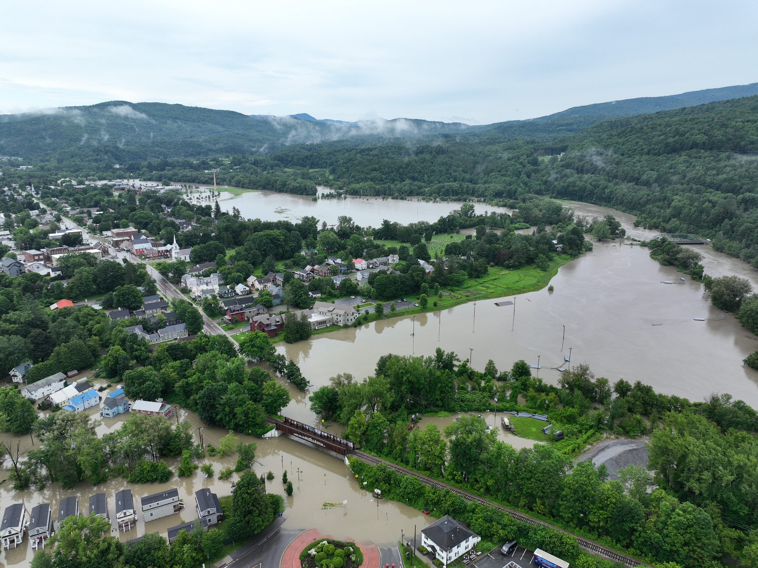
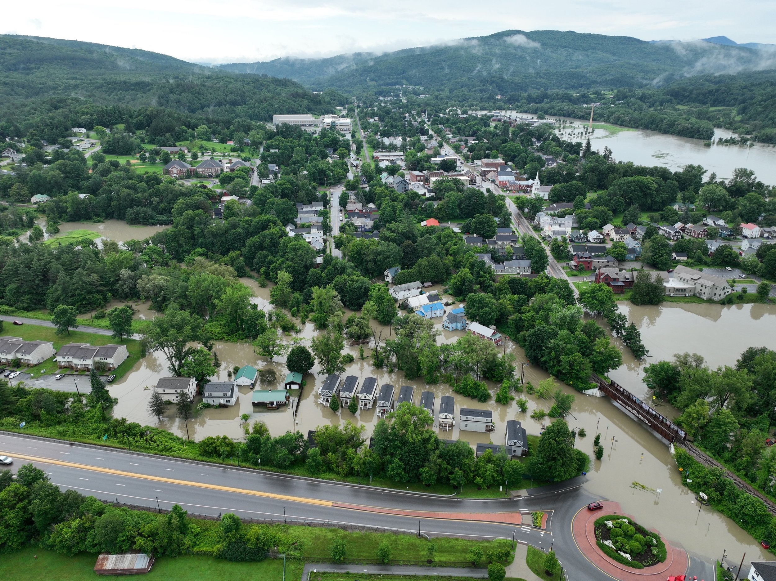
Morning after the storm photos by Vince Franke

Flood safety tips and resources
Stay away from flooded areas and damaged areas
Do not approach or traverse rivers or waterways
Respect detours
Never drive across a flooded road
Do not drive around or across any barricades
For life-threatening emergencies, call 911
For non-emergency assistance, call 211 or text your zip code to 898211 (8 a.m. to 11 p.m. daily), or visit vermont211.org
Traffic and statewide road information: newengland511.org
Sign up for Vermont emergency alerts: vtalert.gov
Track river levels: water.weather.gov
Waterbury local resources online at Waterburyvt.com.
Read more about the flood response in Waterbury and Duxbury here with the latest information about road and business closures, etc.
Waterbury Roundabout reporter Lisa Scagliotti contributed to this report.